
When You Demand Strength and Sea-Keeping

World Speed Record holders with our own vessel and crew
Safehaven Marine’s Thunder Child II’s North Atlantic UIM World Record record run, Arctic Circle and Greenland voyages in 2021
Regrettably Covid 19 had put paid to our plans to undertake our Transatlantic record attempt last year, and due to the continuing Covid restrictions on travel it also resulted in making the Transatlantic run logistically too difficult to undertake this year as well. However with Thunder Child II crew of five:, Skipper Frank Kowalski, Navigator, Ciaran Monks, Drone pilot Carl Randalls, Logistics Mary Power and Engineer Robert Guzik all vaccinated, we decided to undertake a shortened, but still pretty extreme and challenging record run this summer. The new record attempt would be from Ireland to Iceland taking in the first and longest leg of the original UIM record route: Killybegs, Ireland to Reykjavik, Iceland. Living on the boat we then planned to continue voyaging to northern Iceland, then head North West, crossing the Arctic Circle line and on to the Greenland coast. We would then have achieved one of our longstanding ambitions, that being of voyaging beyond the Arctic Circle to see an iceberg in Thunder Child II. Below, the full 4,000nm voyage of Thunder Child in 2021

We sailed Thunder Child II from Cork to Killybegs a week ahead of when we expected a likely looking weather window might appear looking at the long range forecast, this would save us a full days travel during the weather window, a day of which would still be necessary to bring the boat the 350nm up the exposed Irish West coast. The weather window did indeed materialise and on the 7th of July we drove up from Cork to board Thunder Child II that evening. After taking on food provisions locally, provisions that mostly consisted of microwavable meals, sandwiches and a fair selection of junk food enough to last 3 days, we prepared the boat for departure at 3am on the morning of the 8th. The departure time was set by the need to arrive at Castle Bay in the Outer Hebrides after the daily ferry had docked and departed, as the easiest berth for our refuelling was at the ferry’s dock. We had a great deal of logistic support and help from Ruaridh MacLean who arranged our fuel tanker and guided us in, indeed the support we received locally at the ports of call throughout our voyage proved invaluable, especially as a fast turnaround at the two refuelling stops was going to be essential in setting a good record time. The forecast had predicted winds dying down during the night of our departure, and indeed this proved to be the case. However the residual 1.5m swell was on the nose leaving Killybegs, and this made for tough going at over 30kts, especially during the night time passage. This leg was a distance of some 170nm, and once clearing Malin Head, the most Northwest tip of Ireland and turning more North Easterly conditions eased, and once gaining shelter from the Outer Hebrides islands and with a lightening fuel load we were able to run up to over 40kts for the final run to the island of Barra. It’s worth mentioning at this point the capabilities of Thunder Child II in respect of speed and range. Powered by four Caterpillar C8.7 650hp engines with France Helices surface drives, the unique ‘Monocat’ hull form has a Hysucraft hydrofoil between the Catamarans hull sections. The hydrofoil lifts the hull out of the water at speed, reducing drag and allowing for very fuel efficient high speed cruising. The caveat being that the boat has to be travelling at 30kts to sustain this. The ability to ‘get up on the foil’ is greatly dependant on the boats weight, or more specifically the fuel load carried. To ensure longevity and reliability from the engines I only run the boat at a maximum engine load of 80%, the power needed to run at 33kts with 7000 litres of fuel. The engines loads decrease to just 65% with a more normal 3,000 litres of fuel for this size of craft. The cut off point for being able to achieve 30kts cruise in calm seas is 7,500 litres, which gives a theoretical safe range of 700nm factoring an average fuel economy of .1nm per litre, which is very good for a 23m boat weighing around 25 tons light, and 32 tons loaded at speeds from 34kts right up to 50kts. However as with any boat the sea state can have a significant effect on range, and in a bit of weather this can reduce by as much as 20%, so this has to be factored into one’s range calculation. Almost uniquely Thunder Child II is more fuel efficient the faster you go, so being able to keep the speed above 30kts was critical in achieving the greatest range, and if forced to slow down because of weather our range was going to reduce, and this was going to produce a dilemma for us.

Above, The first refuelling stop for Thunder Child II at Castle Bay in the Outer Hebrides before heading out 560nm across the North Atlantic to the coast of Iceland
We arrived at Castle Bay at around 8.45am, thankfully the fuel tanker was waiting for us at the pier and we had a very efficient refuelling stop, with a good few of the local population of the Island turning out to watch Thunder Child II arrive and depart. The island was fairly shrouded in mist whilst we were there, but we could still admire the rugged landscape and of course the picturesque Castle atop a small island in the bay, from which the town gains its name. The aforementioned dilemma we faced was the amount of fuel to take on-board for the 562nm open ocean crossing across the North Atlantic to the coast of Iceland. Theoretically we should only have needed 5,500 litres, and my original plan was to take on 7,000 litres, which I felt gave a safe margin. However looking at the forecast, and considering the general sea state we encountered voyaging to Castle Bay, which was going to be pretty representative of the sea conditions we would face for at least the first 200nm of the crossing, that being light winds but with a residual head sea swell of 1.5m which did have a somewhat detrimental effect on our speed and range on the first leg. However the most uncertain element was the likely sea state we would face for the final 200nm, where freshening winds were forecast. Running out of fuel would obviously have been disastrous, so to be absolutely safe I put 8,500 litres of fuel in her, even though at this weight she would likely struggle with speed initially. It turned out to be the right decision. As we departed Castle Bay running through the calm waters around the islands we were able to run at 30kts with the engine load at just over 80%, which was pretty impressive, however once we cleared the bays shelter and pushed out into the North Atlantic we started running into the head sea swell. Punching into the swell and keeping the speed up over 30kts meant the engine loads were reaching 90%, so I made the decision to reduce speed down to 20kts, at which speed the load was just 70% and run for a couple of hours at this reduced speed just to cover distance and burn off fuel, lightening our load to the point where we could get back up on the foil again without over stressing the engines, as they were going to have to look after us for a few thousand miles as we journeyed to our final destination. After a couple of hours the seas calmed down a bit and our load lightened and we were again able to run at over 30kts.
Our path took us very close to the Islands of St Kilda. This is a place I had always wanted to visit, as over the years Safehaven Marine have built a few passenger craft that run out from the Outer Hebrides Island to St Kilda. It was only a short detour adding a few miles from the most direct path, so it was worth losing a little bit of time to pass close by, where we stopped briefly to check the engine rooms and at the same time fly our drone, capturing some lovely footage of Thunder Child as she passed by the Archipelago, which was pretty wild and foreboding in the mist that was there on the day we passed.

Above Thunder Child II stopped by St Kilda, an archipelago in the North Atlantic, the last landfall before Iceland.
We continued onwards and conditions improved to near perfect, with a mirror like sea, surely a rare occurrence in the North Atlantic, but made for a very enjoyable and comfortable few hours as we travelled North. Around 200nm from Iceland, almost exactly as predicted by the Windy forecasting app which proved incredibly accurate throughout the voyage the wind got up shifting to the South West and freshening. As we moved into the night, the wind and seas increased and it became quite dirty, by no means rough, but when you’re running at over 30kts a 1.5-2m head sea is tiring for such a long duration, no matter what boat you’re in and we got beat up a bit. Thankfully at this latitude it never became truly dark, pretty much remaining like dusk, which when travelling at over 30kts makes for a less stressful passage. Even though out in the Middle of the North Atlantic these not much to hit it’s still better to be able to sea ahead of you, rather than be relying solely on our radars and FLIR camera. We also started to burn more fuel than expected in keeping up the speed in these conditions. This led to quite an anxious few hours during the night when we became a bit concerned as to whether we would make it if we kept up this speed, as range was becoming tight by our continuing fuel burn calculations. Thankfully as morning came conditions moderated and we were able to run at around 38 kts for the remaining miles to the island of Vestmannaeyjabaer, which would be our final refuelling stop before crossing the finish line in Rejkavik.
We arrived at Vestmannaeyjabaer around 5.30am the next morning. Vestmannaeyjabaer has the most spectacular and intimidating harbour entrances I have seen. The entrance lies between steep sheer cliffs and is very narrow, I could only imagine how dangerous it must be for the many fishing boats that operate out of the harbour when returning to port to seek shelter during a storm. Once again our refuelling stop was efficient, with my Friend Óskar Hafnfjörð Auðunsson of Trefjar boat yard in Iceland arranging for refuelling there, its always a relief when you see the tanker on the pier waiting for you, and you know it’s all going to be straight forward and easy. At this point all the crew were pretty tired. Some had managed to get some sleep, but really on a fast boat travelling at speed in a bit of a seaway, even if relatively slight, sleep is difficult at best, all you can really hope for is powernaps, but amazingly this is all you need to keep going. I myself at this stage pretty much hadn’t slept for two days, running on stress and adrenaline, and was pretty knackered. Whilst refuelling we again had a chance to fly our drone, and Carl captured some cool video as we departed Vestmannaeyjabaer with its spectacular cliffs in the background.

Leaving Vestmannaeyjabaer through its spectacular entrance after refuelling heading for the finish line in Reykjavik
The final leg of our record run was some 130nm from Vestmannaeyjabaer to Reykjavik. For the first half of this leg as we headed West it was again pretty tough going, as with no worries about range now we were running Thunder Child pretty hard at up to 40kts as we rounded the Southern edge of Iceland before turning East to run across Reykjavik Bay towards the finish line. Luckily Thunder Child is fitted with military spec shock mitigation seating by SHOXS which certainly help with endurance. We crossed the finish line at Reykjavik at 50kts with Oskar there as the official timekeeper for UIM, setting a time of just under 32hrs to cover the 866nm we had travelled from Killybegs in Ireland to Iceland, with an average speed underway of just over 30kts. Crossing the finish line was a fabulous and memorable moment for all the crew, although it had been tough at times all that is forgotten in the sense of achievement one experiences during such endeavours. During the record run we pushed the boat pretty hard at times, but she never let us down and her Cat engines never missed a beat. One does need a special boat to do such a long distance relatively high speed open ocean voyage, but she was designed especially for this.
Once berthed in Reykjavik marina we were visited by customs and immigration officers. Apparently we had broken every rule in the book, and should have cleared customs in Vestmannaeyjabaer. Mistakenly we assumed that as we were not departing the boat, only refuelling, it was not necessary there and that customs clearance would be at our main destination of Reykjavik, but we were wrong. The customs officers were however very accommodating allowing us to officially clear customs there. Although all the crew had been fully vaccinated we were still a bit apprehensive about immigration, but after the immigration officer checked our Covid vaccination certs we were deemed free to enter Iceland and leave the boat. This was a relief as the thought of having to stay aboard during quarantine was pretty unappealing. Being able to go ashore for a meal and a beer in Reykjavik was wonderful. Iceland had just days before lifted all Covid restrictions, so it was great to be able to go to a restaurant and not have to wear a mask, something we had not been able to do in Ireland for almost twelve months.

Above, entering the Fjord to Isafjorour with its stunning scenery.
After a good check over of the boat that evening and a good night’s rest aboard, we departed for Isafjorour in North Western Iceland to begin the next stage of our voyage, which was to cross the Arctic Circle in Thunder Child II and see an iceberg. Before leaving we spoke with the local whale watching guides who operate out of Reykjavik taking sightseers out into Reykjavik Bay to see whales. Helpfully they shared with us the best spots in the Bay to see them as Carl was keen to get some drone footage of a Humpback whale, and we were all excited about seeing one too. Weather conditions were perfect as we departed and headed out to the Bay, and sure enough we were soon treated to the sight of Minkie Wales and later a solitary Humpback whale which Carl captured some cool drone footage of. We had a very enjoyable voyage up the West coast of Iceland with calm seas and slack winds, stopping regularly to enjoy the scenery along the coast, which was truly spectacular with mountain’s and black volcanic rock formations the like of which we had not seen along any other coastline. As we voyaged along the Northern part of Iceland we ran into fog which was pretty thick, although not bad enough to slow us down, but we were slightly concerned about entering the unfamiliar Fjord and port of Isafjorour in thick fog. Miraculously as we turned into the Fjord the fog began to lift and out of the fog the tops of the mountains that ran right down to the shore began to appear, As we entered the Fjord the fog completely cleared and we were treated to spectacular scenery as we entered Isafjorour. Isafjorour is a small town of some 2600 in population, and is situated between two tall mountains to the North and South. Here again our friend Oskar had arranged for berthing and refuelling for us with the help of his niece who lives there. After refuelling we headed into the small town and had a nice meal there before retuning aboard to turn in early and catch a bit of sleep, as we would be awakening early to head off on what for me was to be the most exciting part of our voyage. We cast off the lines at 5am the next morning, departing Isafjorour to head for the Blosseville Coast of East Greenland.

Above the large flat iceberg encountered calved from the Citronen Fjord, estimated as a quarter of a mile long and wide.
This part of our voyage was undoubtedly the most challenging, as at this time of the year sea ice had not cleared completely off the East Coast of Greenland. I had been studying the sea ice charts and satellite images of the region for weeks preceding and had observed that the ice concentration was retreating and thinning, but could see that sea ice still extended off the coast. Its concentration was mostly 1-3 according to the Egg Charts ice concentration scale, but still even this level was likely going to be too much for Thunder Child to attempt to navigate through with her FRP hull and exposed surface drive props. However there was a break in the sea ice between Scoresby Sund and Kap Barclay that extended right up to the Blosseville Coast. The difficulty was firstly translating the actual coordinates of the sea ice edge from the ice chart into a waypoint on our plotter, and secondly taking into consideration the fact that the most recent ice chart was 3 days old. To reach this break in the sea ice we would have to travel North for some 100nm and then turn West, and head for the coast. This seemed a reasonable and achievable plan at the time, however things would conspire against us.

Above. The largest iceberg encountered in the Denmark Strait, of a beautiful shape and colour, 30m high
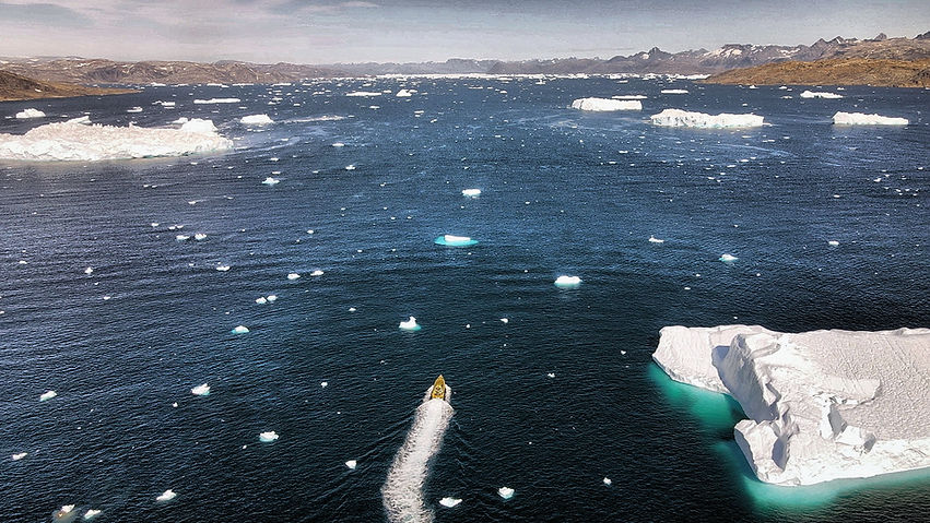
Knowing that there would be no possible chance of refuelling in Greenland, as the Blosseville Coast is completely uninhabited we took on a full fuel load, enough for us to make the Greenland coast and return, a voyage of some 450nm. We left the Fjords at Isafjorour and headed out into the Denmark Strait in calm seas with a long sea swell on our beam. After a couple of hours we ran into the first bank of sea fog. Sea fog is pretty prevalent in the Denmark Strait at this time of year so we were expecting it. We continued on, running North at our most economical speed around 30kts, faster than was ideal in the conditions. But with all eyes vigilantly peering ahead and a close watch on our two radars, one set at long range and the other at short range, we made good albeit stressful progress towards the point on our plotter where the sea ice edge was predicted to be. As none of us had ever navigated in these waters we really didn’t know what to expect regarding icebergs, and at what point out into the Denmark Strait from Iceland we would encounter them, so we all watched the radar and seas ahead with bated breath for our first encounter. Around 70 miles from the Greenland Coast we crossed the Arctic Circle. Suddenly the fog cleared, it had been patchy mostly, but this was the first real clearing with good visibility. The temperature also suddenly dropped, it had been around 8 degrees Celsius as we departed the Iceland coast but in a very short period of time it dropped to just 2 degrees, we guessed that this was because we had run into the Arctic Current. On the long range radar we begin to see targets appear, and from around 12 miles we saw our first sight of an iceberg to much excitement aboard. As we headed towards the target we realised that it was a massive flat piece of what must have once been the ice pack, it was about a quarter of a mile long and much the same wide and about 3m high above the water. It was simply awesome to see and so completely alien to us. Needless to say Carl immediately launched the drone and flew overhead as we circled the iceberg, capturing some amazing footage that showed the scale of the iceberg making Thunder Child II look insignificant in size by comparison. We later discovered that this was most likely calved from the Citronen Fjord, which is most known for producing such large square icebergs.

Above left, the crew toasting with a glass of Jameson’s whiskey cooled by ice from an iceberg. Below. The drone piloted by Carl Randalls was invaluable for recording the spectacular moments during the voyage.

As we studied the radar we could see that there was another fairly large target showing around 12 miles away that we could actually see quite clearly on the horizon. We figured that this would have to be a pretty big iceberg to be seen from such a distance, so immediately head in its direction. As we came closer we could see that it was indeed a huge iceberg. We guessed about 30m high, of a classic jagged iceberg in shape and of a wonderfully white blue colour. This presented us the perfect opportunity to break out the bottle of Jameson’s whisky we had bought from Ireland and toast our voyage with a glass of Jameson’s cooled by a piece of ice from an iceberg. We fished a small piece of ice from the sea that was floating around the large iceberg with our landing net, and proceeded to break up some ice from it for our toast.
We then continued on our route north heading for where we expected the edge of the sea ice to be. As we neared the vicinity we hit very thick fog, pretty much pee soup with less than 50m visibility, which is in effect zero visibility. This forced us to slow right down to 10kts as we know that we were in close proximity to the sea ice pack edge, and one would need to be travelling slowly at this speed in order to have time to alter course for a growler that might appear suddenly ahead of us out of the fog. We always anticipated that our encounter with the sea ice would be fraught with danger, however we had not factored combining that moment with heavy fog, which made it doubly dangerous and pretty stressful. We had figured that when we encountered the ice edge we would be able to skirt the outskirt of it to find the break in it that would allow us to reach the Blosseville Coast. This plan of course depended on good visibility to see far ahead, not be in zero visibility which was the case at that moment. Sure enough eventually we ran into the edge of the sea ice finger that was predicted by the ice chart to be extending off the coast. It must be said that there was absolutely no way we could enter the ice pack, even though by my estimation it was only around 1-2 according to the density scale on the egg chart. Without being able to see far ahead to try and pick a course through it, it was simply impossible, as it would not be possible to turn Thunder Child quickly enough to avoid the small pieces that could damage a prop, let alone the larger growlers, and impacts with smaller pieces of ice would be inevitable. So we decided to head north again shadowing our past track on the plotter to clear water running at slow speed. As we continued ahead of us out of the fog appeared a large iceberg, it had intermittently shown up on our radar, but nowhere near the size that it turned out to be.

Above. A large icebergs eerily shrouded in fog appears ahead of Thunder Child II, one can clearly see how much of the iceberg is invisible under the water. Below left, a high speed run past an iceberg, right, growlers along the edge of the ice pack, impacting with one of these would have been disastrous.
This is one of the problems with depending on radar to spot icebergs, as depending on their shape they can be very hard to spot on radar, and growlers would often not show up to any significant degree. This was a pretty spectacular iceberg, shrouded in fog it was ghostly in appearance and the encounter was quite eerie. Such was the moment that we had to fly the drone to try and record it for posterity, however after a short time flying the drone malfunctioned, and froze hovering around 3m above the water. I pretty much wrote the drone off, but Carl insisted on us trying to recover it by backing the boat down so the aft deck was under the drone and scooping the drone out of the air. Miraculously we were successful in this and saved the drone, and almost as importantly the wonderful footage it had recorded. Possibly the cold and the fog had caused the malfunction.
After this we had to make a decision as whether to continue trying to reach the coast or not. We had to factor a few things. Firstly the danger from trying to continue to do so in the fog. Secondly the likelihood and probability that the fog continued right up to the coast, and after spending what would be several hours at slow speed reaching the coast we would not actually be able to see the coast upon arrival, and the disappointment in that. Lastly we were burning up fuel in our endeavours and we had to be very mindful of our ultimate range capability to make it back to Isafjorour. In the end we made the sensible decision to abandon the attempt to reach the Greenland Coast and head back to Iceland. On the way we were lucky enough to encounter several other fabulously shaped large icebergs on our course, the fog cleared and the sun came out and it was one of the most magical sea voyages I have ever made.

What I thought was really interesting though was the disorientation as to distance one could experience, the edge of the fog banks in the distance created what was like a false horizon, where it appeared as a white band above the sea forming a second horizon which was most disorientating. At one point having a disagreement as to the distance away from us an iceberg was. To me it appeared a small piece of ice maybe 3-400m away, when it was in fact a pretty large iceberg 10 miles away from us, which only became believable to me as we motored towards it and it did not get any bigger. It was indeed 10 miles away from us. This iceberg was one of the most beautiful we encountered, being fully blue in colour, it was an upside down iceberg that had capsized.
The journey back to the coast of Iceland and Isafjorour was wonderful, calm seas, little fog and thankfully a midnight sun at this latitude and at this time of year it never got dark, rather like a dull day at home, which made arriving back in Isafjorour at 2.30am an easy task in daylight rather than night. So although we hadn’t quite made it to Greenland, (we actually got to some 30nm from the coast), it was a fabulous experience and we captured the most amazing photos and video of Thunder Child II floating shimmering like a block of gold against the awesome back drop of an iceberg. What a sight that was! The voyage described here and back to Reykjavik where Thunder Child II was left awaiting its return voyage to Ireland later the next month was some 2,000nm.
Thunder Child II’s voyage to Greenland. By Frank Kowalski

In August 2021 Thunder Child II lay in Reykjavik, Iceland after I and her crew returned to Ireland having completed our North Atlantic record run and Arctic Circle voyage in July. Bad weather had settled in across the North Atlantic preventing her voyage home at the time. Back in Ireland I couldn’t help but bemoan the fact that we had not been able to reach Greenland and the disappointment I felt as it was an ambition I had held for many years. At home in the evenings I could almost imagine standing on her deck in Iceland and seeing Greenland’s coast, as crazy as it might sound considering it was still 420 nautical miles away, but in my mind it appeared close. It had taken so much effort to get her to Iceland, I knew that if I bought her home she would most likely never get back there again, as it's just such a long, long way to get there from Ireland. So I made a decision that if a suitable weather window appeared in August, I would fly back to Iceland and try to get to Greenland this time, recounting the old adage that if at first you don't succeed, try again!
Back in July when we had tried to reach Greenland the first time during our arctic circle voyage from Northern Iceland, conditions were against us. There were two main reasons, firstly sea ice had not by then fully cleared off the East Coast of Greenland. My original planned destination of Tasiilaq was closed in by sea ice, forcing us to try and make the Blosseville Coast further north where there was a small break in the sea ice. Secondly the months of June and July are notorious for fog in the Denmark Strait and off the Greenland coast, in late August and September the likelihood of fog decreases. On this occasion we hit the sea ice edge 30 miles from the coast in heavy zero visibility fog, and it was just too dangerous to continue further and try to reach the coast, forcing us to abandon the attempt. Luckily, indeed a suitable weather window appeared and on the 12th of August I flew back to Iceland. For this voyage my usual crew could not make it due to work commitments, so only myself and Kenny Carroll, who would be my engineer and works for me at Safehaven Marine flew out. Kenny had been disappointed to miss our first voyage as at the time was still awaiting his second vaccine jab, and as such not fully vaccinated like the rest of the crew. Luckily, through friends I had made in Iceland I managed to take aboard two Icelandic crew, Siggeir Palsson and Alex Oddsson in Reykjavik. Although I was prepared to undertake the voyage with just Kenny and myself, it would have been hard going on such a long passage with just the two of us.
On the evening of the 12th we cast off from Reykjavik. My plan was to get the 5 hours of night passage done relatively close to Iceland, so that by the time we closed the waters off Greenland where we might begin to encounter Icebergs, we would be in daylight hours. Greenland’s waters are considered so dangerous due the presence of icebergs and fog that a voyage plan has to be notified to the Greenland Coastguard in advance of any vessel entering its waters 200nm from the coast. The Coastguard must also be updated every six hours as to one’s position, sea and ice conditions and current situation. We did this by relaying massages via satellite communication devices aboard to Mary at our shore base in Ireland. Mary then communicated our information by e mail to the Coastguard. We also provided a link to our live tracking web portal created by Safetrx so they could track our progress throughout our time in Greenland waters. The first 100 miles or so were a bit tough going with a Force 5 wind off our bow, and heavily loaded with fuel we were just making 22kts into the weather. However as forecasted by Windy, (which again proved to be incredibly accurate with its forecasts, at least up to 3 days out), the wind died off, and for the remaining 200 miles we had no wind and a calm sea, with just a swell behind us allowing us to run at over 30kts. Thankfully the dreaded fog stayed mostly away, with us only encountering a few banks of fog throughout the voyage which slowed our progress at times. When 65 miles from Tasiilaq and 50 miles off the nearest coast of Greenland we came upon the first icebergs. These were huge icebergs and awe inspiring, floating like giant sentinels alone in the ocean out of sight of land. It’s always a fabulous moment when you come across your first icebergs on a voyage, so the moment was celebrated by a brew as we drifted peacefully in silence, with Thunder Child’s four engines themselves enjoying a break, as we admired the majesty of the icebergs.
Thereafter as we headed to Tasiilaq the icebergs became increasingly more frequent until as we approached the coast they were everywhere you looked out to the horizon. Finding the entrance to the bay that led up to the town of Tasiilaq was not easy, as the entrance was quite narrow and crowded with icebergs. We also had a degree of trepidation as to the accuracy of our ECDIS nautical charts, as only a very small area of Greenland is accurately mapped due to the regions remoteness. As it turned out the small square of detailed chart around Tasiilaq proved to be very well mapped. However, as we later discovered this was not the case for the surrounding coastline, as at one point during our voyaging along the coast we found our self’s shown to be crossing right over the top of a small island on the chart plotter, when in actual fact we were a few hundred yards off it. Running up the fjord to the town was wonderful, with clear skies and sunshine, with numerous smaller icebergs aground by the shoreline, it really was a picturesque sight. The town of Tasiilaq has a population of 1700 people and is the largest settlement on the East Coast of Greenland, apart from the small settlement of Kulusuk just up the coast, the nearest town to the south is Nanortalik, 400 miles away and 500 miles to the North is Ittoqqortoormiit in Scoresby Sund. The coast line between being completely uninhabited, which shows both the vastness and remoteness of the region. Upon arrival at the single commercial quay where the weekly supply ship berths we were met by the ports harbourmaster, and once the expected formalities of immigration and of course in our current times, verification of our Covid vaccination passports and negative PCR tests had been completed, we were allowed ashore. Kindly the Harbour Master allowed us to stay alongside the commercial quay until Sunday, when the ship was due to arrive. Before it arrived we would have to anchor Thunder Child in the bay, which we had anticipated, but it was more convenient to be able to stay alongside the quay. Needless to say Thunder Child II’s unique looks and her gold livery created quite a stir, (as she would do everywhere she went) amongst the small population drawing many visitors to the quay to see her, all of whom were very friendly and helpful. During our visit we stayed at the Hotel Angmagssalik, which was very comfortable and hospitable to us.
After a good night’s rest, which was well needed, as at this point I hadn’t really had any sleep for 2 days as Thursday night was spent travelling by car, and Friday night was spent at the helm during the crossing from Iceland, which incidentally took approximately 17hrs to make the 420nm across the Denmark Strait. Our plan for Saturday was to head South to the large Sermilik Fjord and then on to the Johan Peterson Fjord at the end of which lay the Bruckner and Heim glaciers. As we travelled along the coastline towards Sermilik Fjord we came upon an abundance of icebergs at the mouth of the fjord and the surrounding sea, I described the sight at the time as ‘the iceberg factory’ where the icebergs were exciting the fjord and drifting out to sea.
As we approached the density of growlers and small pieces of ice increased dramatically calling for constant course changes and great vigilance. The smaller growlers and pieces of floating ice could be very hard to see if there was any swell running or if you were heading into the sun, where reflections in the water looked much the same as small pieces of ice. Sometimes in the calm seas within the fjords one would come across an unbroken line of small pieces of sea ice caused by a tidal eddy. There would often be no way around and the only solution was to come slowly up to the line of ice and just before it take the engines out of gear and let her drift slowly through at about 1kt. Thunder Child II’s FRP hull sure as hell wasn’t built for going through any kind of heavy ice and her four surface piercing propellers were particularly vulnerable. But with this method there was no issue as the small pieces of ice passed gently down her side, and after initially swirling around the transom would clear allowing you to continue on. Throughout our time in the waters around Greenland we were extremely careful and we never hit any ice, as the consequence of damaging Thunder Child’s hull in such a remote region would have been dire to say the least, as there was no facility to lift her out or even beach her, and in just a couple of months’ time the waters would begin to freeze and the area would again become locked in ice. There are different types of ice in Greenland, we saw mostly icebergs of young white ice calved from the ice shelf and glaciers, with only the occasion blue iceberg formed from old ice. There were also many floating ice sheets that had either broken off the ice shelf in the Arctic and drifted down, or remained from the winter’s ice sheet that formed in the Fjords. The most dangerous, at least for us in a small boat was black ice. Black ice is formed from rainwater that congregated in crevasses and froze, the black ice growlers are the most dreaded by Greenlanders as they float almost completely submerged and are transparent. Locally referred to as liquid stones they are very difficult to spot and would put a hole in the hull pretty damn quick if hit at speed.

When travelling around the icebergs, of which we did a lot of flying our drone and capturing our imagery, one had to be very careful. Some 90% of an iceberg is hidden under the water and one could easily get caught out as often the iceberg would extend far out from the visible part one could see. To a certain extent on a sunny day you could see this at sea level from a boat as a light bluish area of sea. However it was only from high up that you could see this clearly, and from our drone we could see the full extent of the iceberg and judge where we could safely go. For the most part icebergs are stable and the larger ones can last 2-3 years, however they are undergoing a continuous process of melt, and erosion from waves. As such at various points in their lifespan they can become fragile and parts can break off unexpectedly causing the iceberg to become unstable. Should we have been too close to an iceberg when this happened there was a very real risk that the iceberg could suddenly capsize and roll over on top of Thunder Child II before she could get out of the way. As we travelled up the Sermilik Fjord the density of growlers and small pieces of ice gradually increased to the point when it was becoming increasingly difficult to find a path through them, and I felt that if we continued on to try and reach the Johan Peterson Fjord it could become dangerous, as there would come a point when it would become impossible to turn or manoeuvre Thunder Child without inevitably coming in to contact with ice. To compound the situation, as we left Tasiilaq fog was beginning to come in towards the land from offshore, and as we looked back it appeared to be entering the mouth of the Fjord. Often fog forms in the cold waters just off the land but doesn’t actually reach over the shore due to the heat coming off the land, but not always. If we had travelled any further and fog had come down on us we would have been in real trouble as it would have been almost impossible to navigate through such a high density of ice in fog, as you wouldn’t be able to see to plot a path ahead, and one would inevitably come into contact with ice. So I decided to not take any chances and head back out of the Fjord. As it happened the fog never came in any further, but in this case discretion was the better part of valour. Arriving back to Tasiilaq that evening we had a pleasant evening at the hotel talking with the other residents, all whom had interesting stories to recount about Greenland.

When travelling around the icebergs, of which we did a lot of flying our drone and capturing our imagery, one had to be very careful. Some 90% of an iceberg is hidden under the water and one could easily get caught out as often the iceberg would extend far out from the visible part one could see. To a certain extent on a sunny day you could see this at sea level from a boat as a light bluish area of sea. However it was only from high up that you could see this clearly, and from our drone we could see the full extent of the iceberg and judge where we could safely go. For the most part icebergs are stable and the larger ones can last 2-3 years, however they are undergoing a continuous process of melt, and erosion from waves. As such at various points in their lifespan they can become fragile and parts can break off unexpectedly causing the iceberg to become unstable. Should we have been too close to an iceberg when this happened there was a very real risk that the iceberg could suddenly capsize and roll over on top of Thunder Child II before she could get out of the way. As we travelled up the Sermilik Fjord the density of growlers and small pieces of ice gradually increased to the point when it was becoming increasingly difficult to find a path through them, and I felt that if we continued on to try and reach the Johan Peterson Fjord it could become dangerous, as there would come a point when it would become impossible to turn or manoeuvre Thunder Child without inevitably coming in to contact with ice. To compound the situation, as we left Tasiilaq fog was beginning to come in towards the land from offshore, and as we looked back it appeared to be entering the mouth of the Fjord. Often fog forms in the cold waters just off the land but doesn’t actually reach over the shore due to the heat coming off the land, but not always. If we had travelled any further and fog had come down on us we would have been in real trouble as it would have been almost impossible to navigate through such a high density of ice in fog, as you wouldn’t be able to see to plot a path ahead, and one would inevitably come into contact with ice. So I decided to not take any chances and head back out of the Fjord. As it happened the fog never came in any further, but in this case discretion was the better part of valour. Arriving back to Tasiilaq that evening we had a pleasant evening at the hotel talking with the other residents, all whom had interesting stories to recount about Greenland.

On Monday we headed North along the coast to the small settlement of Kulusuk with its population of 200 people. Just North of Kulusuk Island we were informed was a smaller glacier that could be reached by boat, so this was to be our destination as I was determined to get to a glacier. And indeed we did reach it, lying between two mountains the glacier meandered down to meet the waters at the edge of its fjord, allowing us to get close to it and fly our drone out over the glacier to capture some wonderful footage of its jagged ice that had been travelling down from the ice cap for thousands of years.
Returning to Tasiilaq that evening and with the ship departed, we were able to again lay alongside at the quay and take on fuel for our return voyage to Iceland. Departing the next morning at 6am we had calm seas for the first half of the voyage eventually catching up with the tail end of a low pressure system that had passed south of Iceland the day before which put a 2-3m following swell behind us. After a 20hr passage we arrived in Reykjavik at dawn on Wednesday, where we would await the arrival of Carl and Mary to help bring Thunder Child II home to Ireland with Kenny and myself, this time via the Faroe Islands.
Eventually Thunder Child II would have travelled nearly 4,000 miles and looked after us in some of the most dangerous and inhospitable seas in the World, she had done us proud, and although at times it was a bit hairy navigating through the sea ice and icebergs, and being so far from land crossing the North Atlantic and especially the Denmark Strait, it was worth every minute and an experience I will never forget, and undertaken in the remarkable boat Thunder Child II is.


VIDEO. Thunder & Ice, Thunder Child II's voyage to Greenland
THE BOAT
XSV20 'THUNDER CHILD II
Thunder Child II is a Safehaven Marine designed and built XSV20, a unique high speed hydrofoil assisted 'monocat' design of 23m L.O.A. She has a maximum speed of 54kts and a cruise speed of 30-40kts. Capable of comfortably accommodating a crew of 5-6 with full live aboard facilities. Powered by four Caterpillar 650hp (2,600hp in total) diesel engines and surface drives.
In 2020 she set the UIM over 50ft class record for Cork-Fastnet-Cork, a distance of 120nm in 2hrs 36 minutes averaging 44.6kts, recording a maximum speed of 53kts on the run. Designed for long distance high speed voyaging, and capable of operating safely in heavy weather, she has a maximum range of 700nm in fair conditions and in 2021 set a UIM World record for Ireland to Iceland accross the North Atlantic, 862nm in 32hrs averaging 30kts.

XSV 20 Principle dimensions / characteristics
L.O.A. 23m / 74ft
Hull length 21.4m / 70ft
Beam overall 5.4m / 17ft 7"
Draft 1m / 3.2ft
Displacement lightship 24,000kg
Fully loaded 30,000kg
Fuel capacity 8,000L
Range 700nm
Crew capacity 9
Seating 5x SHOXS Shock mitigation seats + 4 fixed (2x 4600 series & 3x X8 Series)
4x suspension reclining seats
Berths 6 berths in 3 cabins
Engines 4x Caterpillar C8.7 650hp
Gearboxes 4x ZF 325ATS Two speed
Surface Drive 4x France Helices SDS3L
Air-Conditioning Dometic
Speed Maximum 54kts
Cruise speed 30- 40kts
Survivability 8x watertight compartments
Windows Front 22mm Ballistic, side 12mm poly-carbonate. Houdini UK
Construction FRP Cored Composite


MEDIA Videos


